Wildflower Wanderings
04 Apr 2024
Stretch your legs in Boulder County’s springtime blooms
By Matt Maenpaa
As the daylight lasts longer and the days get a little longer, Boulder’s bluebird skies beg to be basked in. The green starts to flourish once more and the first blooms of spring start to peek through April and May snows. Though the peak of wildflower bloom won’t happen in some parts of the Front Range and Rockies until June, the first colors will be there to join you in shaking off the winter doldrums.
It isn’t hard finding a good hiking trail in Boulder County, with some not even leaving Boulder city limits, thanks to the extensive network coursing through the area. The webs of trails that stretch out, spur off and link up through the foothills make planning a route ahead of time key to a great wildflower hike.
Anemone Point & Mount Sanitas
Starting at the west end of Pearl Street, accomplished hikers and ambitious visitors who feel they’ve acclimated to the altitude can check out one of the more recently redone trails. Relatively new, the Anemone Trail is a rugged loop, connected to the Red Rocks trail around Mt. Sanitas by a half-mile spur.
Though nominally accessible from downtown Boulder, the Anemone loop has some demanding inclines and rocky ground that might challenge the unprepared. It will all be worth it though, with tremendous views of rolling hills and verdant meadows. The height of the trail has a spur aptly named Reflection Point to take it all in.
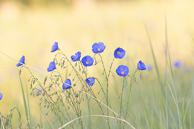
Equally daunting but beautiful, the Red Rocks Loop offers a shorter jaunt perfect for some afternoon exercise. Nearby, Lion’s Lair trail leads up Mount Sanitas, rewarded with views that stretch all the way to Denver on a clear day. On your way through this system, keep your eyes open for sand lilies and blue flax in April, joined by yarrow, prickly pear and yucca blooms in May.
The Anemone Trail
Accessed via Centennial Trailhead or People’s Crossing Trailhead
Distance: 3.4mi
Elevation: 630ft
Difficulty: Hard
Dogs: Must be on leash
Red Rocks Trail
Distance: 1.2mi
Elevation: 377ft
Difficulty: Medium
Dogs: Must be on leash
Mount Sanitas via Lion’s Lair
Distance: 4.1mi
Elevation: 826ft
Difficulty: Medium/Hard
Dogs: Must be on leash
Chautauqua, Flatirons & NCAR
Possibly one of the most well-known and most popular systems in the area, the trails that run from Chautauqua west into the Flatirons and south through NCAR, Green Mountain and Bear Peak are full of locals and visitors alike, looking to take in our local mountain majesty.
With luscious views and well-worn trails that wind through pine forests and wide meadows, it’s easy to see why the parks are the crown jewel of Boulder. Instead of marching up the steep hill from the Baseline Road entrance of Chautauqua, germinate some inspiration with a new starting point.
Skunk Canyon can be accessed from the Deer Valley road parking lot, north of NCAR Road, leading hikers on a gentle walk below the Royal Arch. Nearby, Mesa Trail forms the heart of the system, leading off toward a remarkable eastern view at the Woods Quarry spur, or further south toward Bear Canyon, Shadow Canyon and some worthy peaks to summit.
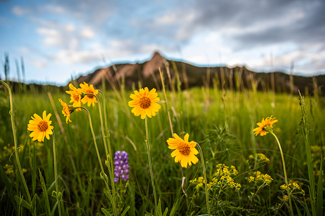
Keep your eyes open for wild blue flax during early mornings in April, joined by golden banner in the meadows. Hillsides and open forests invite lance-leaved chiming bells in a splash of colors, along with wild geraniums and wild irises where water moves nearby. In May, larkspur and lupine dot the trailsides, sprigs of blue and purple offset by the roselike leafy cinquefoil and rare columbines if you’re lucky.
Skunk Canyon and Kohler Mesa Loop
Distance: 2.8mi
Elevation: 587ft
Difficulty: Easy/Medium
Dogs: Welcomed
Bear Canyon to Table Mesa Loop
Distance: 3.2mi
Elevation: 659ft
Difficulty: Medium/Hard
Dogs: Welcomed
Homestead and Mesa Trail Loop
Distance: 3.3mi
Elevation: 613ft
Difficulty: Medium
Dogs: Must be on leash
Woods Quarry and Mesa Trail Loop from Four Pines
Distance: 3.1mi
Elevation: 872ft
Difficulty: Medium
Dogs: Must be on leash
Realization Point & Flagstaff Peak
For a little more elevation and a change of scenery that opens to views of the snow-capped Rockies and nearby Indian Peaks Wilderness, keep driving up Baseline Road past Chautauqua, until it turns into Flagstaff Road. Whether you want a loop or some rugged out-and-back, centering a hike in the area around Flagstaff Peak will surely take your breath away.
The Tenderfoot Trail goes west from Chapman Drive, an easy ramble through the rolling hills with stunning views up the spine of the Front Range, with Mount Audubon peeking over the hills in the West and Rabbit Mountain near Lyons in the north. From there, continue along the Chapman Drive trail or head back the same route.
Starting lower, from Gregory Canyon Road, the Gregory Canyon Trail snakes up a short distance until it connects with Flagstaff Trail and continues up to Realization Point. The density of the canyon trail offers a unique habitat for flowers that need more moisture and shade than sun-drenched, rocky outcroppings can offer.
The beautiful but aptly named death camas has blooms that resemble wild onions or fennel fronds but is poisonous to both humans and animal companions. Out of the canyons, hikers will find the lovely yellow of heart-leaved arnica, as well as more chiming bells and some late blooming pasqueflower.
Tenderfoot Trail
Distance: 1.6mi
Elevation Gain: 275ft
Difficulty: Easy
Dogs: Must be on leash
Chapman Drive Trail
Distance: 2.6mi
Elevation Gain: 994ft
Difficulty: Medium
Dogs: Welcomed
Gregory Canyon
Distance: 1.3mi
Elevation Gain: 1032ft
Difficulty: Medium/Hard
Dogs: Welcomed
Flagstaff Mountain Summit via Gregory Canyon
Distance: 5.4mi
Elevation Gain: 1,512ft
Difficulty: Medium/Hard
Dogs: Welcomed
Before You Go
When planning a hike, it’s always good to dress in layers, and pack plenty of water and sunscreen. Check conditions using sites like AllTrails, as well as visiting the Open Space and Mountain Parks website. Snow can stick around on trails, packing in lots of mud and ice, so supplementing good footwear with spikes and trekking poles can be a life saver.
Resources:
Boulder’s Open Space and Mountain Parks bouldercolorado.gov
Jefferson County and CSU Extension Colorado Plant Database coloradoplants.jeffco.us/plantAbout
AllTrails alltrails.com
Hiking Project hikingproject.com